Transforming data into profitability and accuracy
Our goal is to eliminate uncertainty in the field. We combine precision agronomy with data engineering to maximize the productivity of each plot. Whether through plant counting and geolocation of plots or the development of customized algorithms, we provide the clarity needed for efficient and sustainable management in any environment.
We are your AgroTech partner: we accompany you with regular monitoring throughout the campaign, from sprouting to harvest.
Advanced Decision Support in the Field
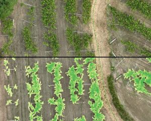
Remote Sensing and Vigor Diagnostics
In-depth analysis of crop health using multispectral sensors. We generate vigor indices (NDVI, GNDVI, NDRE) and calibrated and filtered water stress maps for accurate input and irrigation management.

Crop Inventory and Marl Control
We perform automatic plant counting and precise geolocation of sprouting failures. Ideal for surgical replanting plans that recover 100% of the plantation's productive potential.
Terrain Engineering and Simulations
Photogrammetry and high resolution topography for plantation and infrastructure designs. We include simulations of shadows, solar radiation and irrigation channels, optimizing the use of light and water.
Artificial Intelligence and Algorithms
We develop customized algorithms and AI to predict crops and detect pathologies. We generate variable prescription maps (VRA) compatible with ISOBUS terminals (John Deere, Trimble, Fendt) and DJI Agras drones, automating precision fertilization and irrigation.
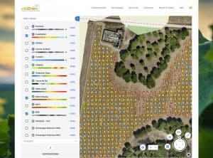
Cloud Platform and Digital Management
Access all your reports, force maps and analysis from our exclusive cloud platform. Visualize the evolution of your farm on any device, download files ready for your machinery and manage your assets with centralized and always available data. Compatible with GIS (QGIS, ArcGIS, CAD, etc).
Innovation and Development of Customized Solutions R&D&I
At vitiDron, if the solution does not exist, we create it.
We collaborate in R+D+i projects providing our analysis capacity with Artificial Intelligence and Artificial Vision.
We design exclusive analytical tools for complex challenges in agriculture, environment or industry, guaranteeing results where conventional software cannot reach.
And how do we do it?
Flights with specific sensors (RGB, Multispectral, LiDAR or Thermal) depending on the objective of the project. We operate with leading technology, including the DJI Agras series for precision applications.
Generation of digital models, orthomosaics and centimeter point clouds.
We apply our software layer and proprietary algorithms to extract real value metrics.
From the screen to the field. Results ready to integrate in agricultural machinery, management software or decision making in the technical department.

